
Ohio Braces for Severe Storms and Temperature Plunge as Cold Front Approaches
Residents across Ohio are preparing for another round of severe weather as a powerful cold front barrels toward the region, threatening strong storms, damaging winds, and a dramatic temperature drop. The system, expected to arrive late Thursday, could bring hail, heavy rainfall, and even isolated tornadoes before temperatures plummet by Friday.
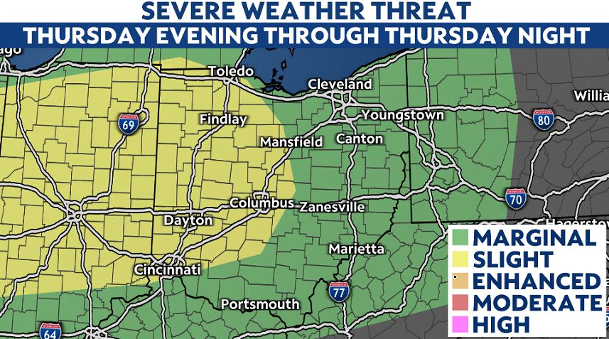
Timing and Threats
The storm system will first bring scattered showers and thunderstorms Thursday morning, but the most intense weather is forecast for the evening. A well-defined line of storms will sweep from northern Ohio toward the southern half of the state, peaking in intensity overnight.
Meteorologists warn that the leading edge of these storms could unleash:
- Damaging wind gusts (potentially exceeding 60 mph)
- Large hail (up to quarter-sized or larger in some areas)
- Torrential rainfall (1-2 inches expected along I-70)
- A low but possible tornado risk
The severe threat is expected to weaken by early Friday, with lingering rain tapering off by midday. However, the abrupt shift in weather will leave Ohioans shivering—highs in the upper 60s to low 80s on Thursday will give way to much cooler air by the weekend.
Why This Storm Could Pack a Punch
Unseasonably warm temperatures ahead of the cold front may act as fuel for stronger storms. Southern Ohio, where highs could reach the low 80s, faces the highest risk of severe activity. The clash between warm, moist air and the incoming cold front increases the likelihood of intense wind gusts and rotating storms.
Preparing for the Storm
Emergency officials urge residents to:
- Secure outdoor furniture and loose objects.
- Charge phones and backup batteries in case of power outages.
- Monitor weather alerts via NOAA Weather Radio or trusted apps.
- Avoid travel during peak storm hours (late Thursday evening).
Flooding could also be a concern, particularly in low-lying areas where heavy rain may overwhelm drainage systems.
What Comes Next?
Once the storms pass, a sharp cooldown will settle in, with temperatures dropping significantly by Friday night. The sudden shift serves as a reminder that spring weather in Ohio can be volatile—swinging from summer-like warmth to winter chills in a matter of hours.
Stay tuned for updates as forecasters refine the storm’s track and intensity.
— Reported by Nexio News
