
Severe Storms Threaten Northern Ohio: Damaging Winds, Hail, and Possible Tornadoes Expected
Ohio residents, particularly those in the northern part of the state, should brace for severe weather Tuesday as a potent storm system moves through the region. Unseasonably warm temperatures and increased moisture are fueling the threat, bringing risks of damaging winds, large hail, and even isolated tornadoes.
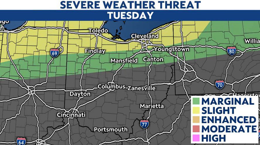
Timing and Impact Areas
The most significant storms are expected along and north of the Ohio Turnpike, including cities like Toledo and Cleveland. Meteorologists warn that the severe weather could arrive in two waves—first in the morning, followed by a stronger round late afternoon through Tuesday night.
- Toledo area: Storms likely between 3 p.m. and 7 p.m.
- Cleveland area: Heavier activity expected from 6 p.m. to midnight
Residents in these zones should stay alert for rapidly changing conditions and have multiple ways to receive weather alerts.
Primary Threats
The storms could pack winds strong enough to down trees and power lines, along with hail that may damage property. While tornadoes are less likely, the risk is not zero—especially in supercell thunderstorms that may develop.
Ahead of the storms, strong non-thunderstorm wind gusts up to 40 mph will sweep across Ohio, adding to the turbulent conditions. Despite the severe threat, temperatures will feel almost summer-like, with highs reaching the 70s and lower 80s.
What’s Next?
After Tuesday’s storms, temperatures will dip slightly Wednesday, but the active weather pattern continues through the week. Additional rain and thunderstorms are possible, keeping flood risks in play.
Officials urge Ohioans to secure loose outdoor items, charge devices, and review emergency plans. Real-time updates from the National Weather Service and local meteorologists will be critical as the system evolves.
— Reported by Nexio News
