
Satellite Imagery Firm Planet Labs Restricts Coverage of Iran and Middle East, Raising Geopolitical Concerns
In a move that has sent ripples through the global intelligence and security community, Planet Labs, a leading provider of satellite imagery, announced on Tuesday that it is indefinitely restricting its coverage of Iran and parts of the Middle East. The decision, which comes amid escalating geopolitical tensions in the region, raises critical questions about transparency, access to information, and the role of private companies in global security. For governments, analysts, and humanitarian organizations reliant on satellite data, the implications are profound—and potentially destabilizing.
The Decision and Its Immediate Implications
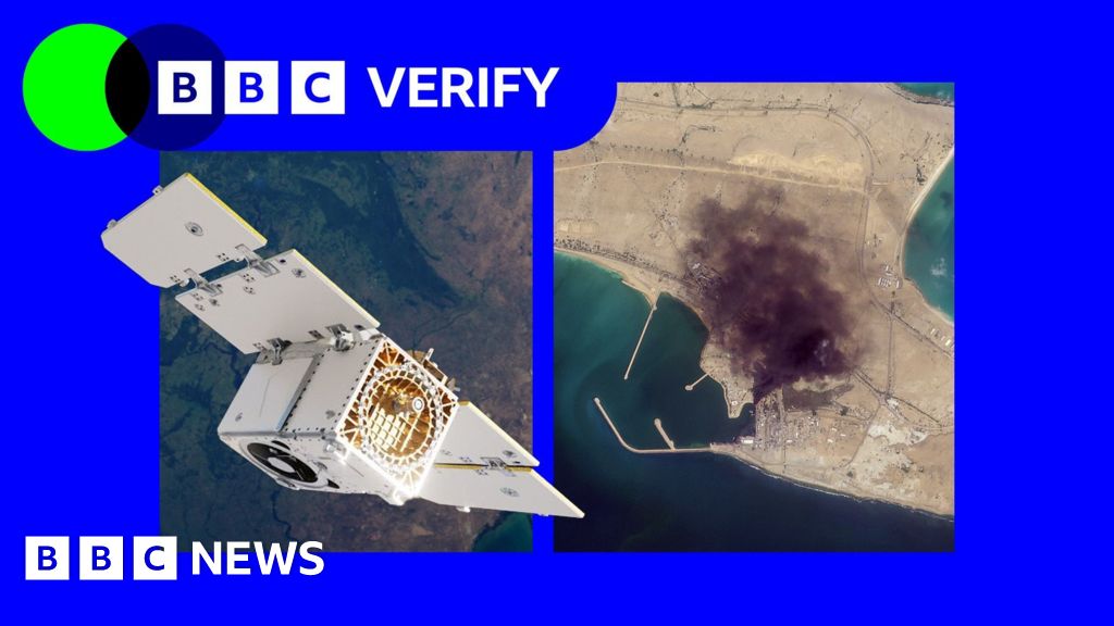
Planet Labs, a San Francisco-based company, operates a vast network of Earth-imaging satellites that capture high-resolution images of the planet daily. Its data is used by researchers, journalists, military strategists, and disaster response teams worldwide. The company’s decision to halt coverage of Iran and unspecified areas of the Middle East was communicated abruptly, without detailed explanation.
Authorities in Tehran have long been wary of foreign satellite surveillance, accusing Western nations of using such tools for espionage. However, Planet Labs has not confirmed whether its decision was influenced by Iranian pressure or broader geopolitical concerns. Analysts speculate that the move could be tied to heightened tensions between Iran and Israel, ongoing nuclear negotiations, or fears of escalating conflict in the region.
The immediate impact is significant. Governments and organizations that rely on Planet Labs’ imagery for monitoring military movements, tracking environmental changes, or coordinating humanitarian efforts in the region will now face a critical gap in intelligence.
Global Context: A Region on Edge
The Middle East remains one of the world’s most volatile regions, with simmering conflicts, proxy wars, and nuclear ambitions shaping its geopolitical landscape. Iran, a key player in the region, has been at the center of numerous flashpoints, from its nuclear program to its support for militant groups across the Middle East.
The timing of Planet Labs’ decision coincides with escalating tensions between Iran and Israel, exacerbated by recent Israeli airstrikes on Iranian targets in Syria and Iran-backed attacks on shipping lanes in the Persian Gulf. Against this backdrop, satellite imagery has become an indispensable tool for monitoring troop movements, missile deployments, and other military activities.
The restriction also comes as world powers, including the United States, European Union, and China, engage in delicate negotiations with Iran over its nuclear program. The 2015 Joint Comprehensive Plan of Action (JCPOA), aimed at curbing Iran’s nuclear ambitions, has been in limbo since the U.S. withdrawal in 2018. Satellite imagery has played a crucial role in verifying Iran’s compliance with nuclear agreements, making Planet Labs’ decision a potential setback for diplomatic efforts.
Why It Matters: The Broader Impact
The ramifications of Planet Labs’ decision extend far beyond the Middle East. Satellite imagery has become a cornerstone of modern geopolitics, enabling transparency, accountability, and informed decision-making. Its restriction raises concerns about the broader role of private companies in shaping global security.
For governments, the loss of reliable satellite data could hinder their ability to monitor potential threats, enforce sanctions, or respond to crises. For humanitarian organizations, it could impede efforts to track migration flows, assess disaster damage, or deliver aid in conflict zones. Journalists and researchers, too, will face challenges in reporting on developments in the region, particularly in areas with limited access.
The decision also highlights the growing influence of private companies in global affairs. As firms like Planet Labs, Maxar Technologies, and BlackSky become key players in the satellite industry, their policies can have far-reaching consequences for international relations.
Furthermore, the move underscores the fragile balance between national security and open access to information. While restricting imagery may align with certain geopolitical objectives, it also risks creating information vacuums that could exacerbate tensions or hinder efforts to promote stability.
Looking Ahead: Uncertainty and Questions
Planet Labs has not indicated how long the restrictions will remain in place or whether they will be expanded to other regions. The lack of transparency surrounding the decision has fueled speculation and concern among analysts.
Some experts suggest that the move could prompt governments and organizations to seek alternative sources of satellite imagery, potentially driving competition in the private sector. Others warn that it could embolden authoritarian regimes to pressure other companies into restricting coverage of sensitive areas.
As the situation unfolds, the global community will be watching closely. The decision serves as a stark reminder of the interconnectedness of technology, geopolitics, and global security—and the challenges that arise when access to critical information is curtailed.
Conclusion: A New Frontier in Geopolitics
Planet Labs’ decision to restrict satellite imagery of Iran and parts of the Middle East marks a pivotal moment in the evolving relationship between technology and global security. In an era where information is power, the move raises critical questions about transparency, accountability, and the role of private companies in shaping international affairs.
As tensions in the Middle East continue to escalate, the absence of reliable satellite data could have far-reaching consequences, from hindering diplomatic efforts to complicating humanitarian missions. For now, the world is left to grapple with the implications of this decision—and to ponder what it means for the future of global security in an increasingly interconnected world.
