
Severe Storms to Sweep Ohio with Damaging Winds, Hail, and Heavy Rainfall
Ohio residents are bracing for a dramatic shift in weather as hot and humid conditions Tuesday afternoon give way to severe storms later in the day. The storms, fueled by an approaching cold front, are expected to bring damaging winds, large hail, and heavy rainfall across major cities in the state. While the tornado risk remains low, meteorologists are advising caution as the weather pattern unfolds.
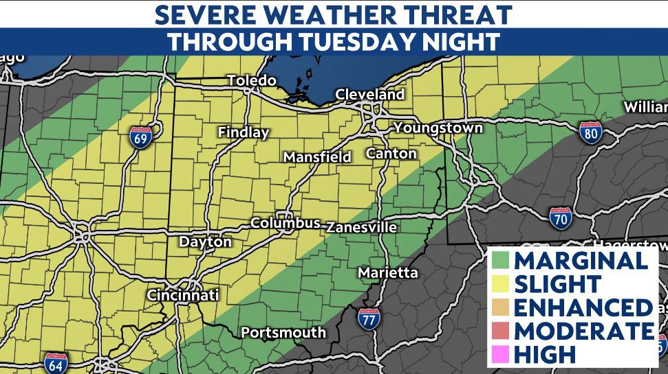
The National Weather Service has issued a Level 2 out of 5 severe weather threat for much of Ohio, signaling a heightened risk of hazardous conditions. The storm activity is predicted to begin in the northwest during the late afternoon and evening, gradually spreading southeastward and continuing through midnight. Residents in affected areas should prepare for potential power outages, localized flooding, and property damage.
Heat and Humidity Set the Stage
The past few days have offered Ohioans a preview of summer weather, with soaring temperatures and high humidity. However, the arrival of a cold front will abruptly end the warm spell. Tuesday’s highs are expected to reach the upper 80s to low 90s in many areas, but Wednesday will bring a stark contrast, with temperatures dropping by more than 20 degrees. Northern Ohio will see highs in the 50s and 60s, while southern regions may briefly touch the 70s before cooler air dominates.
What to Expect During the Storms
The primary concerns for Tuesday’s storms are damaging winds, which could gust up to 60 mph, and large hail, potentially reaching the size of golf balls. Heavy rainfall may lead to flash flooding in low-lying areas, particularly in urban and poorly drained regions. While the risk of tornadoes is minimal, forecasters emphasize that it cannot be entirely ruled out.
Wednesday’s weather will be significantly cooler, offering relief from the heat. However, scattered showers are expected, particularly in southern Ohio, as the cold front exits the state. Residents should remain vigilant, especially those commuting or planning outdoor activities.
Unsettled Weather Ahead
The stormy conditions mark the beginning of an unsettled weather pattern that is expected to persist through the end of the week and into the weekend. Daily chances of showers are forecasted, with intermittent periods of clouds and sunshine. Ohioans are encouraged to stay updated on weather alerts and prepare for rapidly changing conditions.
Safety Tips for Residents
Local authorities are urging residents to take precautions ahead of the severe weather. Securing outdoor furniture, avoiding unnecessary travel during the storms, and having emergency kits ready are recommended. Drivers should also be cautious of slick roads and reduced visibility due to heavy rain.
As Ohio transitions from summer-like heat to cooler, stormy weather, staying informed and prepared will be key to navigating the unpredictable conditions safely.
— Reported by Nexio News
