
Ohio Braces for Severe Storms and Dramatic Temperature Drop This Weekend
Ohio’s unusually warm streak is about to end abruptly as a powerful cold front barrels into the state this weekend, bringing severe storms, gusty winds, and a sharp plunge in temperatures. Residents should prepare for rapidly changing conditions, from Saturday’s storm risks to Sunday’s chilly 40s—a stark contrast to recent spring-like warmth.
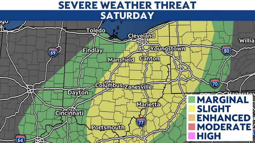
Storm Threat Looms for Saturday
The first wave of unsettled weather arrives early Saturday, with scattered showers and thunderstorms expected along the I-75 corridor. Western Ohio could see gusty storms by midday, while central and eastern regions face a higher risk of severe weather from late morning through the afternoon.
Meteorologists warn that any storm could produce damaging winds, large hail, and even an isolated tornado. However, the overall severe weather potential remains somewhat limited due to cooler daytime temperatures. Still, outdoor plans—from sports events to yard work—could be disrupted.
Temperature Plunge Arrives Sunday
By Sunday, Ohioans will feel the dramatic shift as temperatures plummet from unseasonable 70s and 80s into the 40s and 50s. The cold snap will linger into Monday morning, with wind chills making it feel like the 20s—prompting many to dig out winter coats just days after enjoying near-summer conditions.
Why the Sudden Change?
The shift is driven by a strong cold front sweeping across the Midwest, ending a prolonged period of above-average warmth. While Saturday’s storms may not reach widespread severe levels, the rapid cooldown serves as a reminder of spring’s unpredictable nature.
Safety Tips for Residents
- Saturday: Monitor weather alerts and secure loose outdoor items.
- Sunday/Monday: Layer up—frosty mornings could catch many off guard.
Forecasters urge Ohioans to stay updated as conditions evolve. After this weekend’s rollercoaster, more stable weather is expected by midweek.
— Reported by Nexio News
